
Book : Rand Mcnally Folded Map Western United States - Rand
Cuota promocionada en 6 cuotas de
Llega gratis el miércoles 22 de mayo
Retirá gratis entre el 22 y el 27/mayo en correo y otros puntos
Ver en el mapaDisponible 15 días después de tu compra
MercadoLíder | +10mil ventas

MercadoLíder Platinum
+10mil
Ventas concretadas

Brinda buena atención

Despacha sus productos a tiempo
Medios de pago
Hasta 12 cuotas sin tarjeta

Tarjetas de crédito


Tarjetas de débito


Efectivo


Características del producto
Características principales
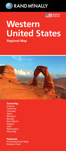
Título del libro | Rand Mcnally Folded Map Western United States |
|---|---|
Autor | Rand McNally |
Idioma | Inglés |
Editorial del libro | Rand McNally |
Tapa del libro | Blanda |
Año de publicación | 2021 |
Otras características
Cantidad de páginas | 1 |
|---|---|
Tipo de narración | Novela |
ISBN | 9780528025174 |
Descripción
- ANTES DE COMPRAR PREGUNTE FECHA DE ENTREGA.
- ENVIAMOS POR MERCADOENVIOS
- PUEDE RETIRAR POR AHORA SOLO POR QUILMES, MICROCENTRO ESTA CERRADO, POR ESO...
- EN CABA (CAPITAL FEDERAL) ENVIAMOS SIN CARGO ESTE PRODUCTO.
- FORMA DE PAGO : MERCADOPAGO
- HACEMOS FACTURA A.
- ELBAZARDIGITAL VENDEDOR PLATINUM
- TODOS NUESTROS PRODUCTOS EN:
https://eshops.mercadolibre.com.ar/elbazardigital
-X-X-X-
- SOMOS IMPORTADORES DIRECTOS, ESTE PRODUCTO SE COMPRA Y SE IMPORTA DESDE ESTADOS UNIDOS, ESTO IMPLICA QUE USTED ESTA COMPRANDO EL MISMO PRODUCTO QUE COMPRARÍA UN CLIENTE DE ESE PAÍS.
- ANTES DE REALIZAR UNA CONSULTA, VISUALICE TODAS LAS IMAGENES DEL PRODUCTO.
Descripción provista por la editorial :
Rand McNallys folded map featuring the Western United States is a must-have for anyone traveling in and around this part of the country, offering unbeatable accuracy and reliability at a great price. Our trusted cartography shows all Interstate, state, and county highways, along with clearly indicated points of interest, airports, county boundaries, and more. Youll see why Rand McNally folded maps have been the trusted standard for years. *Regularly updated, full-color maps. *Clearly labeled Interstate, U.S., state, and county highways. *Detail maps of major cities, a mileage chart, and a Mileages & Driving Times Map. * Indications of parks, points of interest, airports, county boundaries, and more. *Easy-to-use legend. *Detailed index. *Convenient folded size. Coverage Area: States covered: Arizona, California, Colorado, Idaho, Montana, Nevada, New Mexico, Oregon, Utah, Washington, Wyoming. Product Details: Measures 9.5 x 4.125 and folds out to 40 x 28. Scale: 1 = 43 miles.
-o-o-o-
Garantía del vendedor: 90 días
Preguntas y respuestas
¿Qué querés saber?
Preguntale al vendedor
Nadie hizo preguntas todavía. ¡Hacé la primera!